
From DC Comprehensive Plan Amendments
Bill 24-1
April 20, 2021
2300 Overview 2300
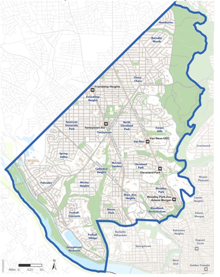
- 2300.1 The Rock Creek West Planning Area encompasses 13 square miles in the northwest quadrant of Washington, DC. The Planning Area is bounded by Rock Creek to the east, Maryland to the north/west, and the Potomac River and Whitehaven Parkway to the south. Its boundaries are shown in the map at left. Most of this area has historically been Ward 3, but in past and present times, some parts have been included in Wards 1, 2, and 4.
- 2300.2 Rock Creek West’s most outstanding characteristic is its high-opportunity, attractive neighborhoods. These include predominantly single-family neighborhoods, such as Spring Valley, Forest Hills, American University Park, and Palisades; row house and garden apartment neighborhoods like Glover Park and McLean Gardens; and mixed-density neighborhoods such as Woodley Park, Chevy Chase, and Cleveland Park.
- 2300.3 Some of Washington, DC’s most important natural and cultural resources are located in Rock Creek West. These resources include Rock Creek Park, the National Zoo, Glover Archbold Park, Battery Kemble Park, and Fort Reno Park, as well as numerous smaller parks and playgrounds. Many of these areas serve as resources for the entire city. Cultural resources include the Washington National Cathedral, American University, the University of the District of Columbia, Howard Law School, and George Washington University’s Mt. Vernon Campus; numerous places of worship ; and several museums, including the Kreeger and Hillwood. The neighborhoods themselves are an important cultural resource, with many historic landmarks and several historic districts, such as Cleveland Park, Grant Road, and the Immaculate Seminary. Rock Creek West is also the location of the Naval Observatory and the home of the U.S. Vice President.
- 2300.4 Despite its residential character, Rock Creek West is also home to a diversity of employment centers, including public and private educational and cultural institutions, local broadcasters, and a large number of foreign missions, including the International Chancery Complex on Van Ness Street. Several large hotels are located in the community, including the Omni Shoreham and Marriott Wardman Park near the Woodley Park Metro station.
- 2300.5 Vibrant retail districts are located around the area’s Metro stations and along its major corridors. Special zones have been created in three of these areas, allowing a mix of retail uses and retaining a human scale and pedestrian character along neighborhood shopping streets. Much of the commercial land use in the area is located along the Wisconsin and Connecticut Avenue NW corridors in shopping districts like Friendship Heights, Tenleytown, Van Ness, and Cleveland Park. With services and retail serving both the neighborhood and broader region, these mixed-use corridors are commuter thoroughfares that are often congested, minimizing pedestrian safety and comfort.
- 2300.6 Since the early 2000s, as many neighborhoods across Washington, DC have seen reinvestment and population growth, commercial corridors in Rock Creek West have experienced competition for customers and for new restaurants and retailers. Although Rock Creek West’s commercial corridors can still rely on local assets, such as proximity to busy transit stations, high-opportunity neighborhoods, and well-travelled roadways, some of the Rock Creek West commercial corridors have faced challenges with retaining businesses and competing successfully with other rapidly growing and popular corridors both within Washington, DC and Montgomery County, Maryland. Some commercial strips experiencing challenges in attracting new retailers or customers have relied largely on restaurants to fill out storefronts. Recent mixed-use developments such as Park Van Ness and Cathedral Commons have helped to add new retail and restaurant choices as well as housing and new patrons for local businesses to major corridors such as Connecticut and Wisconsin Avenues NW. Main Street organizations in Cleveland Park, Glover Park, Tenleytown, Van Ness, and Woodley Park are working to help attract desired retailers and enliven and improve the public realm.
- 2300.7 The Rock Creek West area has significant economic potential, leading to past and present concerns about the community impacts of development The combination of a relatively high-income population, transportation options , high-opportunity and attractive neighborhoods, high-quality retail, and a limited supply of vacant land has led to very strong market demand. The desire to thoughtfully guide growth, while trying to preserve neighborhoods, remains a top priority throughout the community and is a major theme of this element.
- 2300.8 The demand for housing remains consistently strong in Rock Creek West. During the 1980s and 1990s, when Washington, DC was losing residents, neighborhoods west of Rock Creek Park continued to add households. Growth has resulted from a combination of factors, including relatively low crime rates, numerous neighborhood amenities, accessible neighborhood retail, convenient Metrorail (Metro) access, active community organizations, relatively high-performing public schools with strong parental support, and numerous private schools.
- 2300.9 These same factors have created a continuing affordable housing dilemma in the community. The 2016 median sale price for homes in zip codes west of Rock Creek Park exceeded $975,000. Although there are opportunities for new housing development in the area, there continues to be a substantial unmet need for new affordable units and a need to preserve existing affordable and moderate-income options. Increasing the production of affordable and moderate-income units in Rock Creek West is a priority.
- 2300.10 Washington, DC has a strong need to preserve and create affordable and moderate-income housing across all Planning Areas. Rock Creek West offers opportunities for creating low- to moderate-income housing units, particularly where available capacity exists under current zoning, such as near Metro stations. As an Area of High Economic Opportunity, as defined by the US Department of Housing and Urban Development (HUD), Rock Creek West has a role to play both in preserving its existing stock of affordable housing while providing new mixed-income housing to meet Washington, DC’s fair housing goals.
- 2300.11 The preservation and improvement of the natural environment is also a high priority in Rock Creek West. The community is fortunate to have one of the densest tree canopies in the District, several community gardens, the Capital Crescent Trail, and more park and open space acreage than any other Planning Area in the city. However, development on the fringes of the parks has caused erosion and diminished water quality and views in some places. The existing tree and slope protections in the zoning code need to be preserved for the foreseeable future.
- 2300.12 The sense of community in Rock Creek West is reinforced by a particularly active network of neighborhood associations, Advisory Neighborhood Commissions (ANCs), and involved residents. Well-organized citizens associations serve many of the area’s neighborhoods, including AU Park, Chevy Chase, Cleveland Park, Forest Hills, Foxhall, Glover Park, Palisades, Spring Valley, Wesley Heights, Tenleytown, and Woodley Park. A number of historical societies and interest groups are also actively involved in community affairs. Main Street organizations in Cleveland Park, Glover Park, Tenleytown, Van Ness, and Woodley Park are working to help attract desired retailers and enliven and improve the public realm. These groups shape local land use and development decisions, and provide guidance on a wide range of issues relating to transportation, community services, public safety, and other long-range planning concerns.
2301 History 2301
- 2301.1 The first settlements in Rock Creek West developed along roads connecting the port of Georgetown to the countryside north and west of Washington, DC. One of the first settlements was at the juncture of Georgetown Pike (now Wisconsin Avenue) and River Road, where there was a toll station. John Tennally opened a tavern at the intersection around 1790, giving his name to the area now called Tenleytown. Several large estates were developed in the area during the 1800s, including the estate of Colonel Joseph Belt (named Chevy Chase), Major John Adlum’s 200-acre vineyard in what is now North Cleveland Park, and the Henry Foxhall estate in modern-day Foxhall.
- 2301.2 The Chesapeake & Ohio (C&O) Canal was completed in 1843, and a parallel road (now MacArthur Boulevard) was constructed to Washington, DC’s water intake facilities at Great Falls. The canal prompted industrial development along the Potomac River and in the Palisades, including a foundry and several slaughterhouses along Canal and Foxhall Roads. The Rock Creek West area developed strategic military importance during the Civil War, when Fort Reno, Fort DeRussy, Fort Bayard, Battery Kemble, and other fortifications were developed.
- 2301.3 The area remained rural after the Civil War. The Potomac Palisades became popular as a summer retreat for high-earning Washingtonians. Land adjacent to Fort Reno, meanwhile, was occupied by people who had been enslaved and came north in search of homes and land. Their community, dubbed Reno City, remained until the 1930s when the District developed Deal and Wilson schools, and the National Park Service (NPS) developed Fort Reno Reservoir. Another community of persons freed from slavery developed along Chain Bridge Road in the Palisades.
- 2301.4 Development in the Rock Creek West area began in earnest around 1890. In that year, Senators William Stewart and Francis Newlands founded the Chevy Chase Land Company. The company was responsible for the extension of Connecticut Avenue into Maryland, construction of a trolley line, and the development of the residential community of Chevy Chase. Also in 1890, Congress dedicated 1,700 acres along the Rock Creek Valley as Rock Creek Park, which defined development, transportation, and demographic patterns that would shape the District during the century to come. Other defining moments of the era included the groundbreaking for American University in 1893 and the start of construction on the National Cathedral in 1907.
- 2301.5 Rapid residential development took place during the early 20th century as the Rock Creek rail line began operating on Connecticut Avenue and electric streetcar lines were extended up Wisconsin Avenue and through the Palisades to Glen Echo. Many of the large estates were subdivided during the 1890s and early 1900s. The country estate of President Grover Cleveland, for example, was developed as the Cleveland Park neighborhood, and much of the land owned by the Methodist church was developed as American University Park. Row house neighborhoods like Woodley Park, Glover Park, and Foxhall Village were also developed during this period. By the 1920s and 1930s, apartment construction was occurring up and down Connecticut Avenue NW, with structures like Cathedral Mansions (built in 1924) and the Kennedy-Warren (built in 1931) defining the avenue’s image as a desirable residential address.
- 2301.6 During World War II, the federal government razed the country estate of John R. McLean to build wartime housing in what would become McLean Gardens. Specifically, the Defense Home Corporation built a mix of apartment buildings and dormitories for military personnel. After the war, the units were converted to private apartments, and the dormitories were later torn down. The 30-building complex was converted to condominiums in 1980 and houses more than 1,000 residents today.
- 2301.7 By the 1960s, the land use pattern was well established. Connecticut Avenue NW had apartment buildings interspersed with retail shopping areas. Wisconsin Avenue NW still had expanses of single-family residences, but mid-rise apartment and office buildings were being constructed on some blocks. The development of Metro led to additional development in the 1970s, including the University of the District of Columbia and Mazza Gallerie in Friendship Heights. By the late 1990s, almost all privately owned land in the community had been developed. In spite of this fact, much of Rock Creek West retains a small-town character today. The area’s attractive and architecturally appealing and well- maintained housing stock, tree-lined streets, neighborhood-oriented shopping districts, and well-used parks and public facilities make this one of a highly sought-after part of Washington, DC.
2302 Land Use 2302
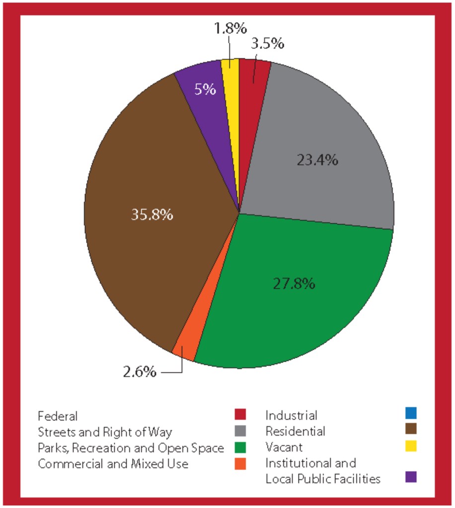
- 2302.1 Statistics on existing land use are estimated from current lot-by-lot property tax data together with additional information on housing units, employment, District and federal land ownership, parks, roads, water bodies, etc. They are not comparable to the statistics included in the 2006 Comprehensive Plan, which were based on a much simpler method. Even large differences between the older and newer statistics may reflect differences in the modeling approaches used a decade apart and not actual changes in land use. Land use statistics for the Rock Creek West Planning Area appear in Figure 23.1. The Planning Area comprises about 8,300 acres, or roughly 19 percent of the District. This total includes 7,961 acres of land and 340 acres of water. 2302.1
- 2302.2 Residential uses represent the largest single land use in the Planning Area, accounting for about 36 percent of the total. Of the residential acreage, 77 percent is developed with single-family detached homes. About 13 percent is developed with semi-detached homes, row houses, and other attached single-family housing. The remaining 10 percent is developed with multi-family apartments and condominiums. Higher density housing is concentrated along the Connecticut Avenue corridor, along Massachusetts Avenue NW between Ward Circle and Idaho Avenue NW, and along Lower Wisconsin Avenue NW. Densities in most of the area are well below the District-wide total, although individual blocks along the avenues contain some of the densest housing in Washington, DC. 2302.2
- 2302.3 Commercial land uses occupy just two percent of the area. Major commercial centers are located around the five Metro stations, in walkable shopping districts along the avenues, and in neighborhood shopping centers like Spring Valley. Institutional uses make up about four percent of the land area. These uses include American University, Sibley Hospital, and the campuses of numerous private schools and religious institutions. There are no industrial uses in Rock Creek West.
- 2302.4 Parks, recreation, and open space comprise 28 percent of the Planning Area. The majority of this acreage is owned by NPS, including Rock Creek Park, the national parklands along the Potomac River, and Glover Archbold Park. Transportation rights-of-way represent about 23 percent of the Planning Area, which is somewhat lower than the District-wide total. Federal government facilities comprise about 3.5 percent of the land area. A majority of this acreage is contained within federal complexes such as the Naval Security Center and the Naval Observatory. Only 1.8 percent of the Planning Area consists of private, undeveloped land.
- 2302.5 Figure 23.1: Land Use Composition in Rock Creek West
2303 Demographics
2303.1 Basic demographic data for the Rock Creek West Planning Area is shown in Figure 23.2. Compared to other areas in the District, Rock Creek West experienced only a modest population growth of nearly 8,500 people between 2000 and 2017. The 2017 population was estimated at 92,399 , or about 14 percent of the District’s total.
2303.2 Compared to other areas of the District, Rock Creek West is less racially diverse and has an older population. Approximately 80.6 percent of the area’s residents are white, which is significantly higher than the District-wide total of 40.7 percent. Only 6.9 percent of the area’s residents are Black, and only 11.2 percent are of Hispanic/Latino origin. The area has a higher percentage of Asian residents than the District as a whole (6.4 percent compared to 3.8 percent). Nearly 19 percent of the residents are foreign born, which is substantially higher than the District-wide total of 14 percent. The area also has a lower percentage of children and a higher percentage of older adults relative to the District as a whole. While 17 percent of the residents are under 18, this was an increase from 12.8 percent in 2000, compared to a District-wide total of 17.5 percent, which has decreased. About 17.2 percent are over 65, compared to 11.9 percent District-wide. The percentage of older adults has increased since 2000 , when it was 15.1 percent.
2303.3 Figure 23.2: Rock Creek West at a Glance 2303.3
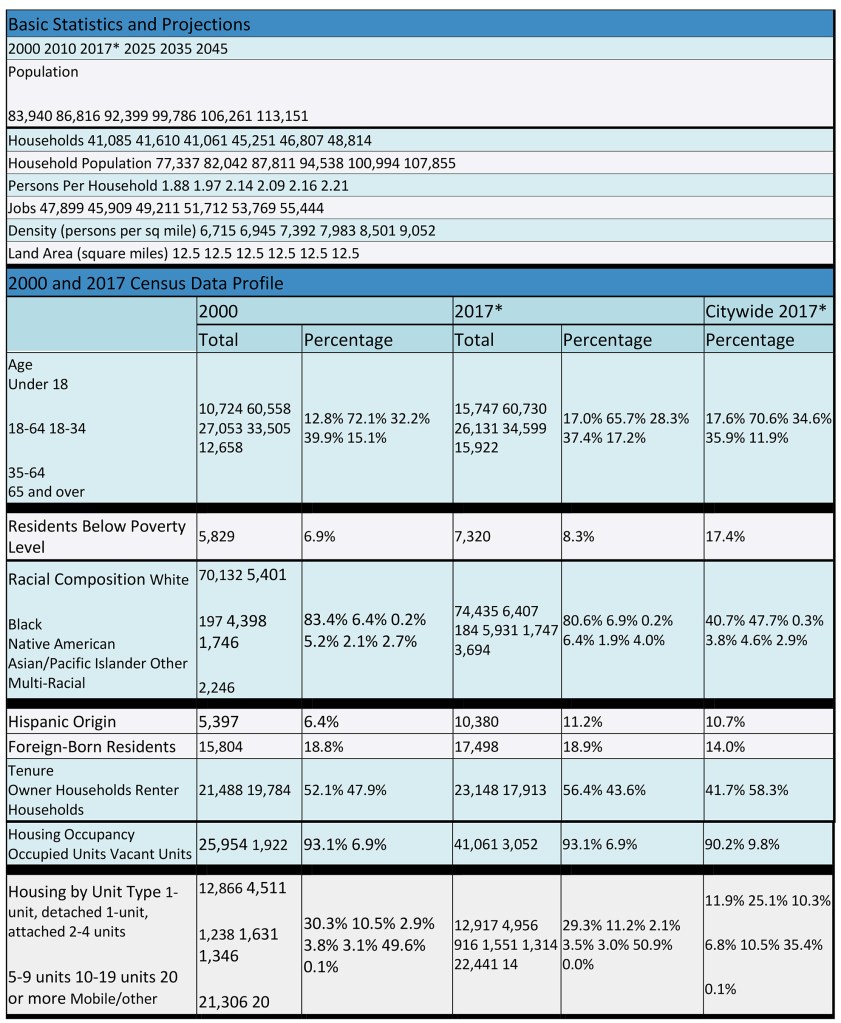
* Source: U.S. Census Bureau, 2013‐2017 American Community Survey 5‐Year Estimates.
2304 Housing Characteristics 2304
- 2304.1 In 2017, 29.3 percent of the housing units in Rock Creek West were single-family detached homes, and 11.2 percent were single-family (one-unit) attached homes (row houses, semi-detached homes, and townhouses). The percent of single- family detached housing is more than twice the District-wide percentage, but the percent of one-unit attached housing is less than half of what it is District-wide (which is 25.1 percent) . At the same time, the Planning Area also contains a significantly higher percentage of units in large multi-family buildings compared to the District as a whole. A slim majority, 50.9 percent, of the housing units in Rock Creek West are contained in multi-family buildings of 20 units of more, compared to 35.4 percent District-wide. 2304.1
- 2304.2 In 2017, 56.4 percent of the households in the Planning Area were homeowners and 43.6 percent were renters. This compares to District-wide figures of 41.7 percent and 58.3 percent, respectively. The percentage of homeowners in the Planning Area has been increasing, whereas renters have been decreasing since 2000. The percentage of vacant housing units in the Planning Area was 6.9 percent in 2017 compared to a District-wide total of 9.8 percent. 2304.2
2305 Income and Employment 2305
- 2305.1 Data from the District Department of Employment Services (DOES) and the Office of Planning (OP) indicates that there were 48,684 jobs in Rock Creek West in 2015 , primarily in professional offices, international organizations, local- serving businesses, public schools, universities, and government. This represents approximately 6.1 percent of the District’s job base, with nearly no net increase in employment in the Planning Area. 2305.1
- 2305.2 The Rock Creek West Planning Area has the highest median income of any Planning Area in Washington, DC. In 2017, the median was $131,394, compared to a District-wide median of $76,649. The area’s high median incomes benefit the District by significantly contributing to the tax base while requiring a lower level of publicly subsidized services. Nonetheless, 8.3 percent of the area’s residents lived below the federal poverty level in 2017, well below the District-wide total of 17.4 percent. Many of the residents below the poverty level were older adults with special housing and transportation needs. 2305.2
2306 Projections 2306
2306.1 Given its largely built-out land area , Rock Creek West is projected to be among the slowest growing areas of Washington, DC over the next 30 years. About 7,000 additional households are forecast for the 2017-2045 period, increasing from 41,061 to approximately 48,100 in 2045. The population of the area is expected to increase from 92,399 in 2017 to 113,151 by 2045. Most of the growth is expected to consist of multi-family housing in mixed-use projects along the avenues.
2306.2 The number of jobs is expected to increase from about 48,684 in 2015 to 55,444 in 2045 . Most of this increase is likely to take place near Metro stations as additional retail and local-serving office development occurs.
2307 Planning and Development Priorities 2307
- 2307.1 This section summarizes the opportunities and challenges residents and stakeholders prioritized during the 2006 Comprehensive Plan revision. During large community workshops, residents shared their feedback on District-wide and neighborhood specific issues. Since the 2006 community workshops, however, some of the challenges and opportunities facing the community have evolved. The following summary does not reflect new community priorities or feedback from either amendment cycle but summarizes the most important issues during the 2006 Comprehensive Plan revision. 2307.1
- 2307.2 Three large Comprehensive Plan workshops took place in Rock Creek West during 2005 and 2006. These meetings provided a chance for residents and local businesses to discuss both District-wide and neighborhood planning issues. Many smaller meetings on the Comprehensive Plan also took place in the community, including briefings and workshops with Advisory Neighborhood Commissions (ANCs) and neighborhood organizations. 2307.2
- 2307.3 There have also been many meetings in the community not directly connected to the Comprehensive Plan, but focused on related long-range planning issues. These meetings have covered topics such as the future development of Upper Wisconsin Avenue NW, streetscape improvements along the Glover Park commercial corridor, and proposals for individual properties. 2307.3
- 2307.4 The community delivered several key messages during these meetings, summarized below:
· Residents of the Rock Creek West Planning Area remain deeply concerned about growth. While there is support for development on underutilized sites along the major corridors, issues of height, scale, character, and density remain a source of concern, as well as a source of debate within the community. The relatively low-density commercial zoning on most of the corridors has not provided the predictability that many residents seek. The reliance on planned unit developments (PUDs) has brought neighborhood amenities but has also resulted in density bonuses that are beyond what many residents find acceptable. The potential impact of density increases on schools, emergency response and safety, infrastructure, traffic, parking, environmental health, and neighborhood character led residents to conclude that the only acceptable growth rate is one that matches infrastructure capacity.
· Rock Creek West has the unique characteristic of containing some of Washington, DC’s most dense and least dense neighborhoods, some of which are located next to each other. Along parts of Connecticut and Wisconsin Avenues NW, multi-story apartment buildings abut single-family homes along rear lot lines. These uses successfully coexist in part because of the significant buffering effects of open space, parking lots, alleys, mature trees and shrubbery, changes in topography, and other screening and site planning measures. Neighborhoods seek assurances that existing buffers will be maintained and that additional buffers, setbacks, and a stepping down in building heights will be provided, if and when, infill development occurs along the corridors.
· Like the rest of the District , Rock Creek West is facing a lack of affordable housing. Home prices here are the highest in Washington, DC and many residents could not afford the homes they live in now if they were first-time buyers today. The conversion of formerly modest apartments to upscale condominiums has created a burden for low- and moderate-income renters, older adults, and workers just entering the job market. On the other hand, these conversions have provided a more affordable alternative to individuals and families who would otherwise have been priced out of the community entirely. There is broad support for requirements to include affordable or moderate-income housing units within new market-rate projects, but the prospect of density bonuses and other zoning flexibility in exchange for these units continues to raise objections. While there is support for development on underutilized sites along the major corridors, issues of height, scale, character, and density remain a source of concern as well, as a source of debate within the community.
· A wider variety of retail choices is needed in some parts of the Planning Area. It was acknowledged that the area does not need public action or the involvement of nonprofit community development corporations to attract retail in the same way that other parts of the District do. However, some neighborhoods still lack the range of goods and services needed to support the basic needs of local residents. High costs have had a negative effect on some of the area’s small businesses, leading to a loss of small businesses and family-owned neighborhood institutions. The community continues to favor neighborhood-serving retail rather than office space along the corridors, both to meet community needs and to avoid uses that would generate commuter traffic.
· Some of the Planning Area’s commercial streets lack the vibrancy of other pedestrian-oriented neighborhood shopping streets. Recent efforts to renovate existing commercial buildings in Friendship Heights have generally been well-received and created a more vibrant pedestrian environment. There is support for development that emphasizes walkability over auto-orientation, provided that height, scale, parking, infrastructure capacity, and other issues can be reconciled.
· Traffic congestion and pedestrian safety are also problematic. The radial street pattern results in very high volumes along major corridors, particularly Connecticut, Wisconsin, Massachusetts, and Western Avenues NW, MacArthur Boulevard NW, and Military , River , and Canal Roads NW. Local trips combined with commuter traffic to and from the Maryland suburbs and I- 495, push many intersections beyond their capacities. As is the case in many parts of the District, major arterials are at Level of Service D or E during peak hours, with stop and go traffic. The prior Ward Plan for this area suggested that traffic be restored to Level of Service B or C yet such conditions cannot be attained without massive road reconstruction and removal of major trip generators. This is neither a realistic nor desirable solution. Consequently, more integrated solutions to traffic control, including bus improvements, bicycle improvements, transportation demand management programs for new development, and more efficient use of existing roadways (such as synchronized traffic signals), are needed.
· Parking is also an issue. On-street parking has been removed in some locations to facilitate traffic flow, which has exacerbated parking needs on side streets. Residential permit parking has helped, but additional parking management measures are needed. Some residents have suggested municipal parking garages. Others have called for limits on development as a way to control parking demand. Still others have suggested that developers build more parking spaces than are required by law, or that the District limit the issuance of residential parking permits. There are pros and cons to these options. One downside of building more parking garages is that they may attract more non-local traffic to the area, particularly near Metro stations.
· The community’s public facilities are experiencing the strains of age and increased demand. While enrollment has fallen at DC Public Schools (DCPS) in other parts of Washington, DC, many of the schools in Rock Creek West are over capacity. Some of these schools are experiencing physical deterioration and are in need of modernization. There continue to be concerns about fire and rescue services, and the difficulties associated with renovating historic fire stations to modern standards. The projected addition of nearly 3,000 households in Rock Creek West by 2025 will likely mean that additional fire and emergency management services may be needed, and that library services may need to be expanded. Some of the recreation centers in the area are lacking the amenities found in other parts of the District or are insufficient. The planned new recreation center at Stoddert will provide a much needed facility not only for the community, but for children at Stoddert Elementary.
· The character of new development is an issue, particularly as more smaller homes are expanded or torn down and replaced with larger homes. While many decry tear downs and mansionization, others believe the District should not overly restrict the scale or design of new homes. Communities like the Palisades expressed interest in the conservation district concept to preserve neighborhood identity without regulating each detailed aspect of architectural design. Related issues confront the older apartment buildings along Connecticut Avenue and some of the historic estates in the community. These properties may have the capacity for additional development under zoning, but such development could reduce the integrity of the sites or structures and compromise the features that allow them to coexist so well with adjoining single-family homes.
· The preservation of the natural environment and improvement of environmental health remain top priorities. Like the rest of the District, Rock Creek West includes areas where storm sewers and sanitary sewers are combined, leading to sewage overflow problems during heavy rains. Tree removal and development on steep slopes in areas such as the Palisades and Forest Hills causes erosion, despite tree and slope protections in the zoning regulations. Spring Valley continues to contend with the effects of discarded chemicals and munitions from World War I-era weapons testing. Residents in the westernmost part of the Planning Area are concerned about proposed dewatering facilities at Dalecarlia Reservoir, while those in Tenleytown are concerned about the health effects of communication antennas. Residents in Friendship Heights continue to be concerned about emissions and ground pollutants from the Washington Metropolitan Transit Authority (WMATA) Western Bus Garage. Along major corridors throughout the Planning Area, residents contend with air and noise pollution due to cut-through traffic and idling vehicles.
· Esthetic improvements are needed along some of the area’s roadways to become the gracious gateways to the nation’s capital they were intended to be. In other areas, aesthetic qualities already exist, and should be preserved from future degradation. This is true on roads traversing national parklands such as Canal Road NW, Dalecarlia Parkway, and Rock Creek Parkway.
· There are far fewer community-based residential facilities (CBRFs) in Rock Creek West than other parts of Washington, DC. There is support in the community for scattering small-scale shelters for persons experiencing homelessness (especially in places of worship), providing social service facilities on the commercial corridors, and accepting small community residence facilities within single-family neighborhoods.
· Institutional uses, including private schools, nonprofits, large nursing homes, colleges, hospitals, and religious establishments, are part of the fabric of the Rock Creek West community. In fact, they comprise almost 660 acres in the Planning Area, almost one-third of the District-wide total. Local institutions provide resources for local families and include some of the most architecturally distinctive buildings in the community. Many of these facilities have structures that do not conform to the underlying zoning. In some instances, tensions have arisen between institutions and surrounding neighbors due to noise, parking, traffic, and other issues. Pursuant to the District’s zoning regulations, the compatibility of these uses should be maintained, their expansion carefully controlled, and conversion to other non-conforming uses avoided. Solutions to traffic, parking, and other issues should continue to be developed so that the quality of life in surrounding neighborhoods is not diminished. 2307.4
2308 RCW-1.1 Guiding Growth and Neighborhood Conservation
- 2308.1 The following general policies and actions should guide growth and neighborhood conservation decisions in Rock Creek West. These policies and actions should be considered in tandem with those in the Citywide Elements of the Comprehensive Plan. 2308.1
- 2308.2 Policy RCW-1.1.1: Neighborhood Conservation
Preserve the low-density residential neighborhoods west of Rock Creek Park . Future development in both residential and commercial areas should be carefully managed to address the existing scale, function, and character of these neighborhoods. Updates to zoning regulations offer the opportunity to create more accessory dwelling units for this area to help absorb a share of the District’s growth and provide a more proportional portion of affordable and moderate- income housing sensitive to existing neighborhood context. 2308.2 - 2308.3 Policy RCW-1.1.2: Economic Development
Given the strength of the private market within Rock Creek West, carefully consider public-private partnerships that provide public space and community amenities and support additional mixed-use development in the area. 2308.3 - 2308.4 Policy RCW-1.1.3: Conserving Neighborhood Commercial Centers
Support and sustain local retail uses and small businesses in the area’s neighborhood commercial centers as outlined in the Generalized Policy Map. Compatible new uses such as multi-family housing or neighborhood-serving office space (above local-serving ground-floor retail uses) should be considered within the area’s commercial centers to meet affordable and moderate-income housing needs, provide transit-oriented development, and sustain existing and new neighborhood-serving retail and small businesses. 2308.4 - 2308.5 Policy RCW-1.1.4: Infill Development
Recognize the opportunity for infill development within the areas designated for commercial land use on the Future Land Use Map. When such development is proposed, work with ANCs, residents, and community organizations to encourage mixed-use projects that combine housing, including affordable housing, neighborhood-serving retail, and commercial uses. s. Design transitions between large- and small-scale development to ameliorate the appearance of overwhelming scale and to relate to context of lower-scale surrounding neighborhoods. 2308.5 - 2308.6 Policy RCW-1.1.5: Preference for Local-Serving Retail
Support new commercial development in the Planning Area that provides the range of goods and services necessary to meet the needs of local residents. Such uses are preferable to the development of new larger-scale or bigbox retail uses that serve a regional market. Destination retail uses are not appropriate in smaller- scale commercial areas, especially those without Metro access. Regardless of scale, retail development should be planned and designed to mitigate traffic, parking, and other impacts on adjacent residential areas. 2308.6
- 2308.7 Policy RCW-1.1.6: Metro Station Areas
Recognize the importance of the area’s five Metro stations to the land use pattern and transportation network of Northwest Washington and Washington, DC as a whole . Each station should be treated as a unique place and an integral part of the neighborhood around it. Mixed-use redevelopment at the area’s Metro stations should prioritize the production of affordable and moderate-income housing and retail uses in a manner consistent with the Future Land Use Map, the Generalized Policy Map, and the policies of the Comprehensive Plan. Design context-specific transitions to be more aesthetically pleasing from development along the avenues to nearby low-scale neighborhoods 2308.7 - 2308.8 Policy RCW-1.1.7: Housing for Older Adults and Persons with Disabilities Maintain and increase housing for older adults and persons with disabilities, especially along the major transportation and commercial corridors of Wisconsin and Connecticut Avenues NW.
- 2308.9 Policy RCW-1.1.8: Managing Institutional Land Uses
Institutional land uses in the Rock Creek West Planning Area should be harmonious with surrounding uses, and potential adverse effects on neighboring properties should be minimized when institutions seek expansion. Redevelopment of institutional land should be compatible with the physical character of the community, the changing nature of the District, and not inconsistent with provisions of the Comprehensive Plan and the underlying zoning rules and regulations. Densities and intensities of any future development on such sites should reflect input from the local community, accommodating student housing on campuses and future infrastructure needs.
See the Land Use Element for policies on the expansion of institutional uses and the neighborhood impacts of private schools and other institutional uses.
- 2308.10 Policy RCW-1.1.9: Conserving Common Open Space
Conserve the large areas of green space and interior open spaces that are common in and around the community’s institutional uses and its older apartment buildings. Where these open spaces are recognized to contribute to the integrity of the site or structure, consideration should be given to reconcile infill with these open spaces . 2308.10 - 2308.11 Policy RCW-1.1.10: Conservation of Historic Estates
Conserve the historic estates in the neighborhoods west of Rock Creek Park, including those that are formally landmarked and those that may be eligible for landmark status. Encourage the future use of these sites to be compatible with their landmark status and protect the integrity of their architectural and landscape design. As development and repurposing of these sites does occur, it should be sensitive to surrounding natural areas and not harm historic resources on the site. The use of conservation easements to conserve open spaces on these properties should be considered. 2308.11
- 2308.12 Policy RCW-1.1.11: Managing Transportation Demand
Support the implementation of transportation demand management programs and other measures to more efficiently use the area’s road network by reducing the volume of vehicle trips generated by new developments. Encourage new developments to provide multimodal transportation options and implement traffic calming to reduce development impacts on surrounding neighborhoods. . 2308.12 - 2308.13 Policy RCW-1.1.12: Reduce Single Occupancy Vehicle Trips
Encourage land use decisions that support multimodal transportation options including walking, biking, and transit use in areas such as the Friendship Heights, Tenleytown, and Connecticut/Van Ness Metro stations to reduce single occupancy vehicle trips. When planned unit developments (PUDs) are proposed in these areas, site design and mitigation measures should prioritize non- automobile modes. Pedestrian and bicycle facilities, enhanced transit stops, and carsharing services should be integrated into site designs , in addition to measures addressing passenger, delivery, and service vehicles. 2308.13
Please consult the Transportation Element of the Comprehensive Plan for policies on traffic levels of service and transportation demand management programs. - 2308.14 Policy RCW-1.1.13: Parking
Support parking management strategies to encourage multimodal options for accessing the area’s residential and commercial districts. 2308.14 - 2308.15 Policy RCW-1.1.14: Bicycle Facilities
Implement moveDC and livability studies to improve facilities for bicyclists, including adding bike lanes and bikeshare stations, where feasible, , along Connecticut, Wisconsin, and Massachusetts Avenues, along MacArthur Boulevard, along Calvert and Abermarle Streets, Broad Branch Road NW (to Rock Creek Park), and at each of the Metro stations. 2308.15 - 2308.16 Policy RCW-1.1.15: Metrorail Access
Prioritize pedestrian, bicycle, and bus access to the five Metro station areas, and improve their visual and urban design qualities. Space for carshare and rideshare vehicles should be provided near the stations where feasible to reduce parking congestion in neighborhoods and to encourage alternatives to vehicle ownership. - 2308.17 Action RCW-1.1.A: Commercial Zoning Assessment
Conduct an evaluation of commercial zoning designations throughout the Rock Creek West Planning Area. Consider the creation of additional neighborhood commercial zones at the Van Ness-UDC, Tenleytown, and Friendship Heights Metro stations, and at neighborhood commercial centers and Main Streets throughout the area. Such zones should promote pedestrian-oriented development and be responsive to community concerns about building height, buffers, and transitions between uses, while promoting locally-owned businesses and mixed- use development. - 2308.18Action RCW-1.1.B: Traffic Flow Improvements
Conduct and implement transportation and livability studies for the area’s major corridors to identify possible traffic flow and safety improvements. These studies should also identify improvements to diminish cut-through traffic, reduce speeding, and promote pedestrian and bicycle safety on local streets, especially in residential areas adjacent to Wisconsin Avenue, Connecticut Avenue, Western Avenue, River Road and Military Road NW. 2308.18
2309 RCW-1.2 Conserving and Enhancing Community Resources 2309
- 2309.1 Policy RCW-1.2.1: Urban Design Focus
Focus urban design efforts in the Rock Creek West Planning Area on its commercial centers and major avenues, historic landmarks, historic districts, and areas with significant environmental and topographical features.
See the Urban Design Element for policies on preserving and enhancing architectural character, including guidelines for height, scale, massing, setbacks, and materials.
- 2309.2 Policy RCW-1.2.2: Scenic Resource Conservation
Conserve the important scenic and visual resources of Rock Creek West, including:
· Views from Fort Reno National Park, which is the highest point of land in the city and a place of historic significance;
· The Potomac Palisades, which should be preserved as a low-density, wooded area above the Potomac River and C&O Canal, with future improvements along the river limited to passive open space, trails, and natural parkland;
· Dalecarlia Reservoir, which is environmentally important because of its large land area and proximity to the Potomac River;
· The US Naval Observatory Grounds, which contain abundant woodlands, are proximate to parkland, and are vulnerable to light and heat pollution;
· Stream valleys, including Battery Kemble Park, Rock Creek Park and its tributaries, and Glover Archbold Park;
· Neighborhoods developed on hilly terrain on or near stream valleys, such as Chain Bridge Road/University Terrace, Barnaby Woods, Forest Hills, Hawthorne, Spring Valley, and Woodland-Normanstone; and
· The Civil War Defenses of Washington, otherwise known as the Fort Circle Parks, including Battery Kemble Park, Fort Bayard Park, and Whitehaven Parkway. 2309.2
- 2309.3 Any future development adjacent to these areas should be designed to respect and maintain their park-like settings and conserve their environmental quality. 2309.3
- 2309.4 Policy RCW-1.2.3: NPS Areas
Conserve and improve the more than 2,000 acres of natural open space in the forested neighborhoods that lie between the Potomac River and Rock Creek Park, including Battery Kemble Park, Glover Archbold Park, the Potomac National Heritage Scenic Area, and the Fort Circle Parks. Support efforts to restore water quality and improve natural habitat, along with capital improvements to enhance trails and provide appropriate recreational features. 2309.4 - 2309.5 Policy RCW-1.2.4: Cultural and Visitor Attractions
Preserve and enhance the cultural and visitor attractions west of Rock Creek Park, including the National Cathedral, the C&O Canal, the Capital Crescent Trail, Peirce Mill, the Hillwood Estate, and the National Zoo. Encourage broader recognition of other attractions in the area, such as the Naval Observatory and the Fort Circle Parks. Ensure that visitor activity can blend positively with quality of life for nearby residents. Implement and maintain traffic routing, transportation and parking management plans, and reasonable visitation hours. 2309.5 - 2309.6 Policy RCW-1.2.5: Historic Resources
Conserve the important historic resources of the neighborhoods west of Rock Creek that are identified in the DC Inventory of Historic Sites, the sites of significance inventoried in the Historic Resources Survey conducted by the DC Historic Preservation Office, the Tenleytown Historical Society, and NPS. Where more intense development is proposed in the vicinity of historic properties, adverse effects should be mitigated through careful siting, massing, and design to respect the character of the historic property and to provide appropriate transitions between the historic property and surrounding areas. 2309.6 - 2309.7 Policy RCW-1.2.6: Naval Observatory
Planning decisions in the vicinity of the Naval Observatory should consider the possible effects of light pollution and take appropriate steps to avoid adverse impacts. 2309.7 - 2309.8 Policy RCW-1.2.7: Fire and EMS Services
Renovate and enlarge fire stations while remaining sensitive to their historic architectural qualities. The number of fire stations should be sufficient to serve the needs of area residents and businesses. 2309.8 - 2309.9 Policy RCW-1.2.8: Schools and Libraries Place a very high priority on the expansion, renovation, and improvement of schools and libraries. The fact that a majority of the schools in this Planning Area are operating at or above capacity should be considered in DC Public Schools (DCPS) facility planning. Changes to school service boundaries, the expansion of existing school facilities, and/or development of additional school facilities should be aggressively pursued so that school overcrowding is proactively addressed.
- 2309.10 Policy RCW-1.2.9: Active Outdoor Recreation for All Ages and Abilities Expand recreation grounds where and when feasible, with a particular emphasis on athletic fields for activities such as soccer, softball, and regulation baseball. A skate park, playgrounds, and other outdoor spaces for children and youth of all abilities are needed.
- 2309.11 Policy RCW-1.2.10: Community-based Residential Facilities
Encourage the development of small-scale, community-based residential facilities on scattered sites within the Planning Area, and social service counseling and referral facilities on the commercial corridors. Additional group homes and community-based residential facilities should be accommodated. Local religious institutions should be encouraged to host small shelters to provide for persons experiencing homelessness, , and to provide other needed social services or housing facilities, taking into consideration issues of liability, security, and adequacy of facilities.
See the Environmental Protection Element for additional policies on stream valley parks, limits on impervious surface coverage, expansion of the tree and slope protections in the zoning code , urban forestry, air quality, aircraft noise, and development adjacent to parkland. See the Urban Design Element for policies on conserving natural landform and topography. See the Parks, Recreation, and Open Space Element for policies discouraging the placement of buildings on parkland.
- 2309.12 Action RCW-1.2.A: Combined Sewer Separation
Continue efforts to separate storm and sanitary sewers within the area’s stream valleys, with a priority on rehabilitating the combined sewer in Glover Archbold Park . 2309.12
See the Infrastructure Element and Environmental Protection Element for more information on combined sewers.
- 2309.13 Action RCW-1.2.B: Palisades Open Space Conservation
Conserve the historic linear open space that once supported the Palisades/Glen Echo trolley line, with its unique scenic vistas that it provides for public benefit. Consider rehabilitating the trestle bridges to accommodate a walk/bike trail. 2309.13
- 2309.14 Action RCW-1.2.C: Wellness Center Development
Develop a wellness center in the Rock Creek West Planning Area, partnering with existing facilities that serve all ages and community groups to provide decentralized programming, activities, and services to the area’s large population of older adults . 2309.14 - 2309.15 Action RCW-1.2.D: Façade Improvements
Encourage urban design and façade improvements in the established commercial districts along Wisconsin Avenue and Connecticut Avenue NW. 2309.15
2310 RCW-2 Policy Focus Areas 2310
- 2310.1 The Comprehensive Plan has identified three areas in Rock Creek West as Policy Focus Areas, indicating that they require a level of direction and guidance above that in the prior section of this Area Element and in the Citywide Elements. These areas are shown in Map 23.1 and are listed in Figure 23.2. The policy focus areas include:
- · Connecticut Avenue corridor
- · Wisconsin Avenue corridor
- · Van Ness Commercial District
Each Policy Focus Area is addressed below. 2310.1
- 2310.2 Figure 23.3: Policy Focus Areas Within and Adjacent to Rock Creek West 2310.2
Within Rock Creek West
- 2.1 Connecticut Avenue Corridor
- 2.2 Wisconsin Avenue Corridor
- 2.3 Van Ness Commercial District
Adjacent to Rock Creek West
- 1 Mount Pleasant Street
- 2 18th and Columbia Road
- 3 Dupont Circle
- 2310.3 Map 23.1 Rock Creek West Policy Focus Areas 2310.3

2310.4 Two Future Planning Analysis Areas are located along Connecticut Avenue NW and Wisconsin Avenue NW. Within those Analysis Areas, additional finer- grained small area plans are needed at Friendship Heights, Tenleytown, Chevy Chase, Cleveland Park, Forest Hills, and Woodley Park, and may be appropriate at other areas. 2310.4
2311 RCW-2.1 Connecticut Avenue Corridor 2311
- 2311.1 From the Taft Bridge across Rock Creek, Connecticut Avenue NW extends 3.5 miles northwest to the Maryland state line. Along the way, the avenue passes through the Woodley Park, Cleveland Park, and Van Ness/UDC commercial districts (with Metro stations of the same name at each location), as well as the Chevy Chase commercial district at its northern end. The avenue is a broad, attractive boulevard for most of its length, handling over 30,000 vehicles on an average day. The areas between the commercial districts are generally developed with mid- to high-rise apartments and condominiums, although there are pockets of less dense development as well
- 2311.2 Land use issues vary from one segment of the corridor to the next. The Woodley Park and Cleveland Park segments are historic districts and contain almost no undeveloped land. In Woodley Park, two large hotels contribute to ongoing parking and traffic issues . Cleveland Park’s historically vibrant cluster of neighborhood-serving retail spaces and services. This area has experienced challenges in recent years from limited nearby population growth and competition from other growing and revitalized commercial destinations. In 2016, the Commercial Market Analysis and Enhancement Strategy for Cleveland Park identified four opportunities to help Cleveland Park businesses adapt to the changing competitive context and attract additional customers:
- · Grow and strengthen the Cleveland Park Business Association;
- · Retain and expand Cleveland Park’s customer base in its primary market area;
- · Capture a larger share of existing vehicular and transit commuters along Connecticut Avenue; and
- · Attract more visitors from other neighborhoods in Washington, DC and Maryland, and National Zoo visitors.
- 2311.3 Since the completion of the Commercial Market Analysis and Enhancement Strategy for Cleveland Park, community resources and business efforts have shifted toward the Cleveland Park Main Street organization. Additionally, a larger emphasis has been placed on capturing existing transit and multimodal commuters along Connecticut Avenue NW.
- 2311.4 While the corridor is largely built out, there remain opportunities for redevelopment and renovation to support the future vitality of commercial districts and to create much needed affordable and moderate-income housing. Retail strips along Connecticut Avenue NW could benefit from well-designed infill redevelopment or renovation and improved retail and service amenities.
- 2311.5 Policy RCW-2.1.1: Connecticut Avenue NW Corridor
Sustain the high quality of the Connecticut Avenue NW corridor. The positive qualities of the corridor, particularly its architecturally appealing, older apartment buildings; green spaces; trees; and walkable neighborhood shopping districts, should be conserved and enhanced. Continued efforts to improve traffic flow and parking should be pursued, especially in the commercial districts. 2311.5 - 2311.6 Policy RCW-2.1.2: Infill Development
Recognize the opportunity for additional housing, including new affordable and moderate-income units, with some retail and limited office space along the Connecticut Avenue NW corridor. - 2311.7 Policy RCW-2.1.3: Cleveland Park Retail Enhancement
Support retail enhancement strategies for Cleveland Park to grow and strengthen the local business association, continue to attract and serve local residents, capture a larger share of Connecticut Avenue commuters as business patrons, and attract more visitors from outside neighborhoods. - 2311.8 Action RCW-2.1.A: Large Hotel Sites
Future proposals for the Omni-Shoreham and Marriott Wardman Park hotels should include analysis of impacts on adjacent residential and commercial areas, prepared by property owners. . Proactively address ongoing issues at the hotels, such as motor coach and visitor parking.
2312 RCW-2.2 Wisconsin Avenue Corridor 2312
- 2312.1 Wisconsin Avenue extends 4.5 miles north from the Georgetown waterfront to the District border, where it continues beyond the state line into Bethesda, Maryland. The road pre-dates the 1791 L’Enfant Plan. At one time, it was one of the main commercial routes connecting the Port of Georgetown with communities farther north and was lined with houses and estates, some of which remain today. Today, Wisconsin Avenue serves as the primary commercial and civic corridor for several District neighborhoods, including Glover Park, Cathedral Heights, Tenleytown, and Friendship Heights.
- 2312.2 The mix of uses along the avenue is varied. Its lower portions include pedestrian- oriented shopping, mid- and high-rise apartment buildings, and prominent institutional uses such as the Russian Embassy and the National Cathedral. Farther north, the avenue passes through lower density neighborhoods, with a mix of retail uses, mid-rise office buildings , places of worship, private schools, and other institutional uses. For several blocks on either side of the Maryland line, the avenue passes through a regional commercial center at Friendship Heights. The regional center includes large department stores, office buildings, and hotels on both the Maryland and District sides. 2312.2
- 2312.3 After years of planning and review, new mixed-use development has been completed on Wisconsin Avenue NW in recent years, including Cathedral Commons near McLean Gardens and a few residential buildings in Tenleytown. Along the corridor, smaller infill projects are adding new residents. Large tract projects at the old Fannie Mae building and neighboring 4000 Wisconsin Avenue NW are approved to bring several hundred new homes and commercial space, and the private schools on the corridor are also expanding. While the Friendship Heights Metro area has urbanized rapidly north of Western Avenue NW, there have been few changes on the District side. With changes underway and growth extending up Wisconsin Avenue, directed and coordinated planning is needed around both Tenleytown and Friendship Heights Metro station areas.
- 2312.4 The Tenleytown and Friendship Heights Metro stations are important multimodal transit hubs that serve as termini for crosstown bus lines, as well as private institutional shuttles. Both station areas offer opportunities for transit-oriented redevelopment to improve streetscapes, create convivial public spaces, diversify the shopping experience, and create new housing, including affordable housing. Friendship Heights is a regional center, and Tenleytown is a multi-neighborhood center, each with opportunities for new retail and residential uses. Given the high land values in the neighborhoods along Wisconsin Avenue NW, redevelopment projects are an opportunity to increase the limited number of affordable and moderate-income housing units in the Rock Creek West Planning Area.
- 2312.5 Friendship Heights and Tenleytown are transit-accessible neighborhoods that will contribute to the sustainable and equitable growth of Washington, DC as new development arrives along Wisconsin Avenue NW. Thus, several core issues must be addressed as plans for any of the sites around the Metro stations or along the corridor move forward. Any redevelopment along the corridor should promote walkability and create a more attractive street environment. The impact of new development on traffic, parking, infrastructure, and public services should be mitigated to the greatest extent feasible. The scale and height of new development on the corridor should transition appropriately to nearby single-family homes, while the design of new buildings should reflect their urban transit-oriented context.
- 2312.6 Urban design improvements can make the Tenleytown Metro station area a more attractive and better connected community hub in the future. With busy public schools, parks, a library, commercial uses, and new residential projects, the pedestrian, bicycle, and vehicular connectivity throughout the Tenleytown Metro station area remains an urban design challenge. In 2014, the Washington Metropolitan Area Transit Authority and District Department of Transportation completed a joint study of pedestrian access to the Tenleytown Metro station and recommended physical changes to address safety and access at this busy multimodal area. Amenities, such as public art, more attractive facades, and street trees, should be encouraged. Attention should also be paid to reducing pedestrian- vehicle conflicts, both across streets and within sites, and to ensuring safe pedestrian access to both Metro station entrances. 2312.6
- 2312.7 Policy RCW-2.2.1: Housing Opportunities
Pursue the opportunity for additional housing, including affordable and moderate- income housing, with some retail and limited office space on Wisconsin Avenue and underdeveloped sites west of the Friendship Heights Metro station. . 2312.7 - 2312.8 Policy RCW-2.2.2: Tenleytown and Friendships Heights Metrorail Station Areas Support coordinated planning for Wisconsin Avenue’s Tenleytown and Friendship Heights Metro station areas, extending north from Van Ness to the Maryland state line at Western Avenue. Planning considerations for the corridor should:
- · Use the public transit infrastructure and maximize Metro and bus access;
- · Enable merchants to upgrade existing businesses, attract new customers and new business establishments, and provide neighborhood services;
- · Provide for the development of new housing for a mix of incomes;
- · Conserve existing low-density residences in the vicinity, and the surrounding institutions and local public facilities, by mitigating the adverse effects of development;
- · Ensure that planning and building design is sensitive to the area’s topography, existing architectural assets, street layout, and pedestrian circulation patterns;
- · Promote safe and comfortable pedestrian and bicycle circulation to parks, schools, transit, and shopping, as outlined in the Rock Creek West II Livability Study;
- · Enhance a robust public life on the corridor, with key public spaces that function as places where neighbors and visitors want to stay, linger, and enjoy; and
- · Partner and collaborate with public and private institutional and educational facilities along the corridor.
- 2312.9 Policy RCW-2.2.3: National Cathedral
Any development adjacent to the National Cathedral should complement its setting and mitigate direct traffic impacts on the Cathedral’s operations. At the same time, the Cathedral’s traffic, parking, and activity impacts should not diminish the quality of life in the surrounding neighborhoods. - 2312.10 Policy RCW-2.2.4: Wisconsin and Western Avenues NW
Any changes to facilitate through-traffic on Wisconsin and Western Avenues NW should be accompanied by pedestrian and bicycle safety measures and ease adverse effects of traffic on local streets . - 2312.11 Policy RCW-2.2.5: Land Use Compatibility Along Wisconsin Avenue NW Future development along Wisconsin Avenue NW should be architecturally sensitive to adjoining residential neighborhoods . Use a variety of means to improve the interface between mixed-use districts and lower-scale residential uses, such as architectural design, the stepping down of building heights away from the avenue, landscaping and screening, and additional green space improvements. 2312.11
- 2312.12 Policy RCW-2.2.6: Livability in Rock Creek West
Continue to evaluate transportation safety and quality of life issues for all users of the street network and identify concrete actions to increase transportation options and safety. - 2312.13 Action RCW-2.2.A: Zoning and Design Measures
Continue to work with the community, the ANCs, and local property owners to address concerns regarding building density and height, PUDs and related density bonuses, and architectural design in the Planning Area. Zoning techniques should be considered to break up the auto-oriented commercial appearance of much of Wisconsin Avenue NW and instead create a more pedestrian-oriented street, distinct in function and visual character from adjacent residential areas. - 2312.14 Action RCW-2.2.B: Livability
Implement the recommendations in the Rock Creek West II Livability Study completed in 2011 and subsequent completed livability studies. - 2312.15 Action RCW-2.2.C: Wisconsin Avenue NW Planning
Craft a coordinated vision with the District and community to better understand the realities of change along northern Wisconsin Avenue NW to inform future development and manage growth on the Wisconsin Avenue corridor at the Tenleytown and Friendship Heights Metro station areas. A plan will identify opportunities for urban design, commerce, housing, mobility, culture, public space, and community facilities to preserve a high-standard urban quality of life and advance District policies promoting inclusive prosperity.
2313 RCW-2.3 Van Ness Commercial District 2313
- 2313.1 At the Van Ness Metro station on the Connecticut Avenue corridor, the commercial district is a multi-neighborhood center with a shopping district, institutional and office buildings, and several mid- to high-rise residential buildings. The area includes the 20-acre campus of the UDC, which has an enrollment of more than 5,000 students, as well as the International Chancery Complex.
- 2313.2 Recent improvements to the Van Ness commercial district include the new UDC Student Center, the Park Van Ness redevelopment, and the creation of the Van Ness Main Street organization. However, this section of the corridor experiences a challenging street environment that is not welcoming to pedestrians, with an excess of hardscaped surfaces and noted parking problems. A lack of distinctive facades and storefronts offers a limited range of retail goods and services. Meanwhile, ground-floor retail space has been lost to institutional and school uses. Opportunities exist for greater synergy between UDC and nearby shopping areas along Connecticut Avenue NW.
- 2313.3 A Campus Plan for UDC was completed in 2011 to guide campus growth and development at Van Ness through 2020 at its flagship location. The Campus Plan recommends optimizing the university’s facilities, providing an environment for cultural exchange, enlivening the surrounding community, and greening the campus. As the Campus Plan is implemented, efforts should be made to improve the public space around the Metro station and make future facility development compatible with the surrounding neighborhood. 3
- 2313.4 In 2016, OP in partnership with community members and UDC, completed the Van Ness Commercial District Action Strategy to improve the corridor, with a focus on public space, retail, sustainability, and commercial opportunities. The Action Strategy includes new streetscape and façade improvement recommendations.
- 2313.5 Policy RCW-2.3.1: Public Space in Van Ness
Enhance the linear public space on both sides of Connecticut Avenue NW with larger landscaped areas and increased café seating where appropriate. Create focal points with public art and activate plazas with temporary placemaking and other programming. - 2313.6 Policy RCW-2.3.2: Retail in V an Ness
Support Van Ness Main Street and the ANC in efforts to develop a more cohesive and vibrant retail environment, focusing on creating top quality retail space near the Metro station and developing a coordinated marketing approach for Van Ness. - 2313.7 Policy RCW-2.3.3: Sustainability in V an Ness
Support stakeholder collaboration in Van Ness to enhance sustainability in the Van Ness commercial district. Incorporate green infrastructure into the landscape amenity zone as part of any major streetscape work by the District or a private property owner - 2313.8 Policy RCW-2.3.4: Commercial Opportunities in Van Ness
New building construction and major renovation projects should produce high- quality retail space that engages with the sidewalk and increases housing near the Metro station where possible. - 2313.9 Policy RCW-2.3.5: UDC and Van Ness Community Continue to enhance coordination and communication between UDC officials, Van Ness Main Street, and the surrounding Van Ness community on issues such as parking, traffic, property maintenance, and facility development. UDC and community stakeholders should collaborate to leverage the university’s cultural resources and promote activities that can enliven the street and serve the community.
2313.10 Action RCW-2.3.A: Van Ness Streetscape Improvements
Improve the streetscape on Connecticut Avenue in Van Ness to support commercial revitalization of ground-floor retail, enhance public life on the street, and reduce impervious area between building face and curb. 2313.10


We believe in the power of shared vision and sustained commitment to create dynamic communities for all people, regardless of income.
Email: info@nwopcdc.org
NW Opportunity Partners Community Development Corporation
